Routes
Route 7: Dénia - Ondara - Beniarbeig - Tormos - Pantano de Isbert - Orba - Pamis - Ondara - Dénia (Page 2 of 2)
Itinerary
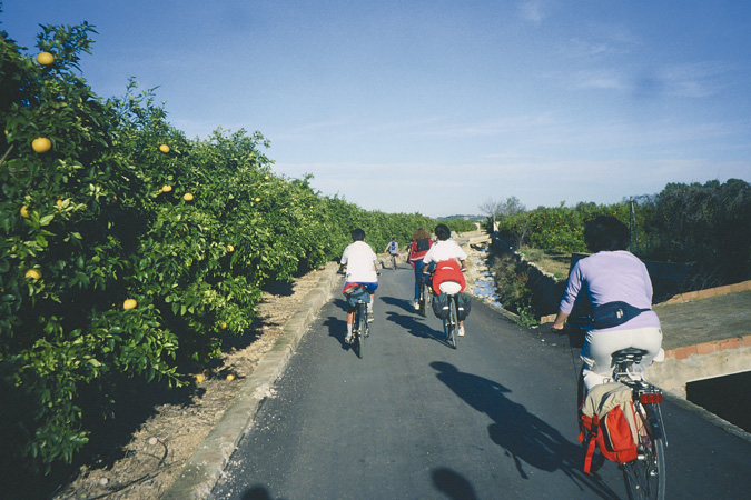 Pedaling through orchard fields.After visiting Dénia, to begin our route we head for "CAMPSA" petrol station located at the city exit towards Ondara. A dirt road on the right is the only one still remaining from the old Dénia-Carcaixent railroad design, dismantled in the 70's. A few signposts from that time can also be considered. We set our distance meter to 0 and start. At the end of the street (0.19) we see a stop, go down the ramp to the right and immediately turn left. We reach a roundabout (0.56) and continue behind "Don colch"n" shop. After passing a few industrial buildings we soon find ourselves surrounded by orchards.
 The Alberca River.We pass by the Francisco Merle garden on our right (1.69), one of many estates belonging to this noble family, owners of the Marqués de C‡ceres winery. The noble XIX century house has a number of beautiful towers lending the building a castle-like appearance, considered a Building of Cultural Interest along with the nearby raisin storage house. We cross a small canal (2.27) and continue left ignoring the way leading to the restaurant "Tossal del Carmen". We reach a junction on the road with a palm tree in the middle (2.53) and proceed left. We reach a stop signpost(3.19) and continue along the asphalted way ahead of us where a house named Ludmila is located. At the next stop signpost (4.50) we arrive at "Casa de Beniadla", with a sun clock on its faade. We turn right and then immediately left. We arrive at another road (5.96) then turn left and next take the first road right towards Ondara. We reach a road; before us we see "Villa Vicenta" (6.60) at which point we continue left. Shortly after we leave by the cemetery on the left and arrive at "Carrer de Dénia" in Ondara (7.17).
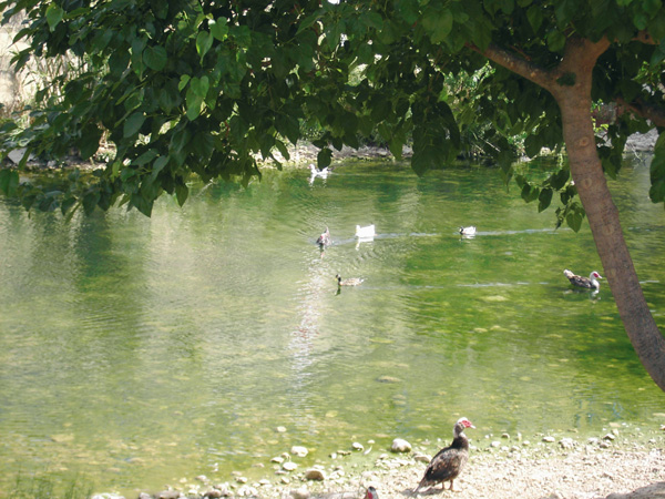
 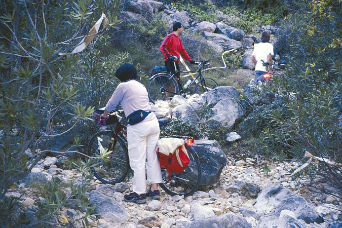 Difficult pass. Isbert.We go right and at the end (7.40), we turn right once more following a ring road that soon after runs parallel to the Alberca riverbed (7.86). We arrive at a bridge and we see Plaza del Convent and City Hall on the left. At this point we stop the distance meter (8.02) to visit Ondara. We start it at "Carrer Mariano Benlliure" right where "Repsol" gas station is located. To resume our route, we head for the end of that street and turn left to proceed along an asphalted way. At the stop signpost (8.08) we continue straight. We pass beneath the new ring road and under the motorway. Once we reach the following stop signpost (9.35) we continue right to enter Beniarbeig. Then we go to the right (9.48) on the road passing under the Girona river bridge, in whose calm waters large numbers of ducks pleasantly swim. From here we can visit Beniarbeig.
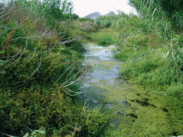
 The Girona River.Our route then keeps along the way that passes by the sports complex and which leads us out of town. We reach a motorway and before us we see "Cam’ de Fond—s" (10.14) along which we proceed. We ignore a road on the right (10.67) and shortly after we ride across a model airplane field on our left, where we can enjoy a good exhibition on Sundays. We arrive at a road (11.14) with an electricity pylon on the left where we turn right. We reach a crossroad (12.25) with a house on the left. On the right we see Sierra de Segaria and opposite a series of mountains and Vall de Laguar where we head for. Almost without noticing, we will start gaining altitude to arrive at Isbert damn. We go all the way straight. On reaching a road, (12.71) we continue left. Then we pass a small dip (13.10) and continue right along "Cam’ de les Plantades". We arrive at a road (14.31) and continue left to immediately turn right (14.49) into "Cam’ de Peris". At such altitude we can admire some of the excellent views of this prelittoral plain filled with orchards, the Montg— on the right and the Sierra de Segaria opposite us. We reach a stop signpost (15.26) and turn left towards Vall de Laguar. Benidoleig appears to the left, where we can go by taking one of the roads in that direction. We find a number of ways on our left and right but we always continue straight ahead. We come across a sign reading "Fomento, Excelent’sima Diputaci—n Provincial de Alicante" and a way on the right (16.62), along which we will proceed. We reach a crossroads (17.66) where a little farther we can see four large pine trees and a stone house. We turn a left here, then pass a white house with a small power pylon, which actually is an irrigation water pumping motor (18.88) and right after will we see a semi-asphalted way on the right along which we continue. At the irrigation reservoir we turn right (18.50) and pass a ford (18.56) and in the middle of the slope we continue left following the painted arrow on the wall (19.12). If we look closely we will soon see the Fontilles wall on the left, at the foot of the famous "Cavall Verd", the only leper colony still standing in Europe. With only a few people there currently suffering from this illness, the place is becoming a nursery home for the elderly. Soon we will see Tormos. As we cross the motorway (20.31) we enter the small town of Tormos along the first street on the left, at the end of which we find the Casa de Cultura and "La Almassara" bar (20.68). The route continues left along Avenida Blasco Ibáñez, at the end of which we turn right (20.79). The way is asphalted in the beginning but then turns into a dirt track. The Fontilles wall can be seen better now. We reach another asphalted road (22.09) and then we ride straight ahead. We are bordering now the last orange tree plantations to enter a more rugged zone, with some slopes up and down, and where traditional dry-farmed crops abound with almond, carob and olive trees. We come near the most spectacular and natural zone of this route as we get beeper into the Girona river valley. Soon will appear the marks of a PR ("short route"), which we will follow. The pine tree woods come into sight alternating with some oak trees as well as other vegetation common to the Mediterranean: oleander flowers springing along the river bed and scent plants such as rosemary and thyme announce their presence with a pleasant aroma.
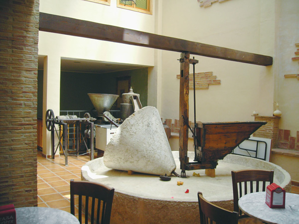 Almazara. Tormos.Spectacular rock walls show numerous niches and a large variety of colours. The strata from different geological layers appear crooked and disjointed due to the incredible tectonic forces exerted here long time ago. We reach a ford (24.13) and then a way heading toward the pumping station and to our destination: the dam base, located only 400 meters away. The way may be have a chain blocking the access. In this case we will have to cover the 400 meters separating us from the damn following the stony riverbed signalled by the yellow and white PR marks, among oleander flowers that we see on our left. Once we cover this stretch, we see a small pumping station on the right. We go a little further in direction of the spectacular gorge before us and we notice that the PR trail turns and goes up to the left (24.58). To come near the base of the damn, it is better to leave our bikes here and continue on foot. On warm days we can relax and enjoy the pleasant shade right next to the damn. We return to our bikes and take on the trail going up to a tunnel (24.80), not very long but quite enough to require the use of lights or a torch. After leaving the tunnel, the trail turns narrow in front of a house and exits onto an asphalted way surrounded by thicker vegetation of pine and cherry trees. The achieved altitude enables us to witness some amazing views of the entire valley and its broadening into the great prelittoral plain. We go out onto a road (26.21) and continue left on a pleasant slope down, as we have reached the highest point of our route, so the return to Dénia, located at sea level, will be entirely downwards. We reach a stop signpost (27.90) and follow to the right as stated by the sign towards Callosa de Segura, to enter Orba soon after (29.09). If we wish to hang around the streets, as always we stop the distance meter at the yellow post indicating the name of the location.
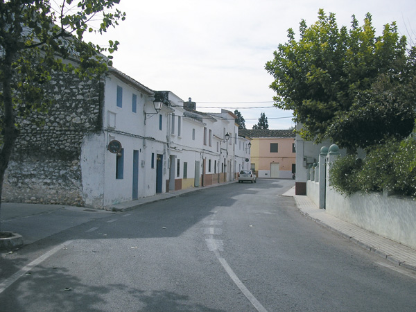 Pamis Street.To resume the route we will have to retrace our steps. Right after the Stop signpost and the sign towards Tormos, we take the first way on the right to soon start a slight way down. A little further on, we continue straight ahead leaving the "Capsó" building complex (29.29) on our right. At the next junction on the road (29.66), we see a "Fomento" sign, and continue left among fields of almond and olive trees. Soon after we leave a way on the left (30.12) and continue parallel to a large reservoir on our right. We reach a road and continue on the left (30.56). Ignoring a road on the left (31.21) we arrive at the same crossroads with the four pines we past earlier (32.37) and continue straight on the main asphalted way. We reach a Stop signpost (33.56) and we proceed always straight. Further on (34.43) we reach a stop once more and we continue straight also onto another Stop signpost (34.52), where we will turn left. We reach another Stop signpost and continue left on the road (34.66). We will pay attention to enter on the right through the "Assagador", (35.12). A few meters farther (35.40) we see the house with the small power pylon and a road on the left through where we proceed. We reach a crossroads (35.86) and continue straight ahead to see a sharp bend to the left, with another electrical tower (36.97), and continue straight. We reach a Stop (37.40) then turn right and at only 20 meters we continue left on a narrow yet asphalted road. Shortly after we pass next to the old Pamis cemetery and arrive at a road (38.10). We proceed right to enter the municipal district of Ondara soon after. We pass before the church of Pamis and continue on the left to get across the town. We reach a road (39.30) that will take us to Ondara on the right. At the sign to Ondara (39.69) we stop the distance meter. Suggestion: enter along "Carrer Blasco Ibáñez" street on our left, as is less busy.
To resume, we head for the "Intermarché" supermarket and start it at the end of Segaria street. We turn left and although it is short, we can take advantage of the cycle lane on the pavement. The second road on the left (39.93) indicates "Partida Xebix" (Ondara) along which where we continue, riding past the municipal pool. We reach a Stop signpost (41.08). We are now on the outskirts of El Verger. We proceed straight and take the first road on the right (41.17). We reach a road (42.50) and continue to the left to immediately take the first way on the right (42.58). We reach the junction of "Assagador del Palmar" (44.21) and continue straight ahead to another Stop signpost (45.10) where we continue straight. We reach another Stop signpost (47.90) and we find ourselves behind "Natura Garden". We continue on the right. At the next Stop signpost (48.25) we turn to the left. After the roundabout (48.42), we continue past the "Lidl" supermarket to arrive at Dénia in a few minutes (49.21).
Previous page