
Routes
Route 23: Cocentaina - Muro de Alcoy - Gaianes - Beniarrés - Lorcha - Villalonga - Potríes - Beniflá - Beniarj" - Real de Gandía - Gandía
(Page 2 of 2)
Itinerary
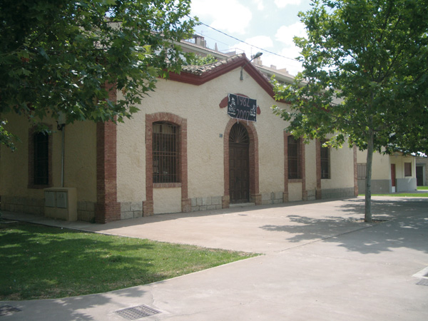 Former Muro railway station in Alcoy.After visiting the town, we shall look for the crossroads of the Avinguda de Xátiva and the avenue of the País Valencià, at the exit towards Valencia. Opposite we can see a two-storey brick building with a neon sign, "Fiat Eurotaller", and on the right, another building with a green & black façade and a "BDD" sign. Between them we can see a dirt track with a signpost banning vehicles over 2 m-wide to park. It is just there that we will set the counter to zero. The former railway track runs along this path, which we will walk along for a while. We will reach a "give way" signpost (0.26) and we will go on straight along Calle Denia, among old houses and industrial premises. The asphalted track ends here (0.71) and we keep walking some metres along the dirt track. Unfortunately the greenway was cut by a roundabout, so we will turn left and take the road (0.80) to keep on the direction to Alquería dÕAsnar and go under a bridge. We reach a roundabout (0.98) and we will take again the former layout of the track, moving along a dirt track (Camí de la Arpella), where a signpost shows "Obras de acondicionamiento del antiguo camino del ferrocarril" (improvement works of the former railway path). We are pedalling now between olive trees and country houses. We will peer in the background at the town of Muro de Alcoy and its church, standing out over the houses. We will reach a roundabout (3.55) and we can see the old train station opposite it, where we can stop the distance meter to visit the town. We go on with our route, and leaving past the two following roundabouts we go on straight as far as the traffic lights (3.99). We keep straight along carrer Gandía, where the train to Muro de Alcoy formerly left the town. Unfortunately, a bridge is missing a bit farther, so at the end of the street (4.30) we will move to the left and we take the first path on the right (4.34) to go down and overcome the ravine. After the short but strong way up, we will arrive at a small road (4.84) and we keep on to the right. We are again between olive fields. Even if the path is quiet, the space is shared with cars, so we have to be careful. We reach a stop signpost (6.05) next to a fountain. Opposite we have the Sierra de Benicadell (Benicadell Mountains). We move again along the layout of the former railway track which today is, as we can see, an asphalted country lane, and where we can also see path signposting.
  Gandía.Later on, we go past a pine forest where we find la Font de la Carrasca (6.90). We reach a stop signpost (9.82) and we arrive at Gaianes. We go up the street on the left and we take the second on the right (9.94). We leave past the "Bar Restaurante Piscina" and we head for the chemist's and the along Carrer Mare de Déu de la Llum. We ignore then Carrer del Forn, which is no-entry, and then we follow to the right. We keep along Carrer Beniarrés as far as the end, where we turn to the right to go down towards the road (10.24). Just before reaching it, we keep left (10.31), along a dirt track parallel to the road, which is the greenway anew. We keep straight as far as reaching a road (11.87), and just opposite we have a former gatehouse which is being refurbished. Unfortunately, we cannot keep on moving, since again a bridge is missing again. To overcome this lap we have to turn to the right on the road (11.93), and keep along it as far as Beniarrés (12.82). We get into the village where the yellow signpost indicating the town is, and we will take the second street on the right, calle de la Alameda. We keep on the second on the right (13.09), calle de la Iglesia. We follow along Carrer San Antonio, and then along carrer Doctor Orero, leaving past the public library. There usually is a street market for fruit and vegetables on Sunday. We turn into the first on the right, which leads to the road (23.29). Next to it we will notice another asphalted path on the left, with a ban on vehicles over 10 Tm; let's follow the said path (13.39). We will reach a tunnel (13.54) for which we will need a torch. Little after the tunnel we will peer the entire valley with Lorcha at the back. We will reach a stop signpost (14.31) and we will follow along the asphalted path opposite, next to a FEDER signpost. This is a very pleasant lap, alternating farming lands, terraced slopes, abandoned houses, pine forests and mountains.
 The castle and former Lorcha railway station.Some kilometres after, we start seeing the Lorcha castle ruins, which are endowed with a very singular aspect, almost ghostly in the middle of this landscape. We arrive at Lorcha former station (20.00). If we wish to visit the village, we can stop the distance meter and keep on the path on the right. The route goes on straight to get into its most spectacular stage: the Racó del Duc. Here the Serpis River has dug a narrow gorge also taken advantage of by the former railway layout, and which we are ready to cross. Even if the soil is somehow stony, this will not prevent us from enjoying the beautiful places we will come across. We leave the first tunnel behind (22.80). Later on, next to the signpost "coto privado de caza" (private game preserve), the path forks (25.03). The railway track is still on the left, but as the bridge is missing, we go down the path on the right to cross over the other bridge. We go through three tunnels more. Once we pass the last and longest (28.68) we will spot a signpost that shows "Camino sin salida" (no way out) (28.76). Few metres ahead, opposite the Mare de Déu factory, we find the monument to the Virgen de la Fuente. According to tradition, a woodcutter found a box with the Virgin inside, floating on the river upstream. This Virgin is the patron of Villalonga, and since then, a procession is held to that place on the third Sunday in October. We quit the track on this point, as there is another bridge missing ahead, and we go up another dirt track on the right, which accounts for the steepest slopes of the entire route. We will reach a road next to a quarry (30.77), and we kept to our left. Shortly after, we will see the river bed again, from which we went away, and the entire valley planted with orange trees, which will keep us company as far as Gandía. After a strong descent, we will come across a group of houses and a restaurant, and on our right, we will find the Reprimala fountain (32.08).
 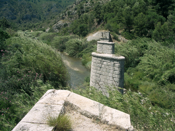 Former railway track without a bridge.We arrive at a "give way" signpost (34.38) next to a brick building, which is IES Vall de la Safor (a Secondary State School). If we want to visit the municipality, we can stop the distance meter on this point. We go across the roundabout and we keep straight along Carrer La Vía. In the following roundabout, we keep along the pinkish pavement to take the greenway again, which we can spot in the background, this time as a dirt track again. We will reach a road (35.40) and we keep on the dirt track we find opposite, some metres on the left. We ride parallel to the road as far as another one (37.34), where we turn right to enter Potríes where the yellow signpost is (37.66). Leaving behind the small roundabout, we keep along Carrer de les Corts Valencianes (37.82) as far as the following roundabout (38.15). We have the Town Hall on our right. If we wish, we can stop the distance meter here to visit Potríes. We keep straight riding next to bar "Vicente". At the end of the street, at the stop sign (38.40) we turn left passing by an old mill with a large chimney, turned into a restaurant today. Just before exiting the road, we keep to the right (38.72) on the dirt road next to which are found the remains of a gatehouse. We exit the road (39.45) and we keep straight in the direction of Beniflá. This is a short lap but with heavy traffic, and therefore, we will be extremely careful.
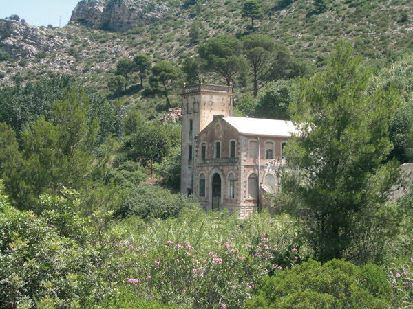 Fábrica de la Luz (the light factory).We reach a roundabout (39.87) and we turn left to enter Beniflá. We keep on the right along calle Pas de Xátiva and calle Safor as far Carrer de Joan Rico where we turn right (40.17). At the end of the road we have to cover a small lap on foot as it is a no-entry way. We go on along Carrer de San Marc as far as Centro de Formación Profesional (Vocational Training Centre) "La Safor" (40.55). If we want to visit the village, we can stop the distance meter. In order to keep on, we will cross the bridge over the Serpis River on the left, and we take the first asphalted track on the right (40.89). We will soon spot the Real de Gandía, which we are heading for. We go over another bridge (41.45) and we keep right on the path with the signpost banning to drive over 40 km/h. We take a sharp bend on the left, ignoring the path that stems straight ahead (41.69). We cross the motorway over a bridge (42.83) and little after, once having going past a greenhouse, we arrive at an asphalted path (43.19), and we keep on the right to ride into the Real de Gandía. At the stop signpost (43.35) we border the square and keep on the left along calle Libertad (43.43). After the stop sign, we keep straight along the street opposite. We reach a walk (43.78) with a small fountain and a monument made up of red tubes devoted to the Maulets. We turn right into Avinguda Jaume I, at the end of which, at the give way signpost (43.98) we can stop the distance meter to visit the village. Otherwise, we keep on the left and we leave Real de Gandía through the industrial estate. We will reach a roundabout (44.459 and we keep straight. We ride under the motorway and we turn right heading for a group of old houses in the background. We will reach a stop (45.13), next to which we can see a church in ruins. Opposite we find a cycle lane that we follow on our right and which leaves us very close to Gandía urban centre (45.49).