 Senderos a Pie - Guía de Senderos de pequeño recorrido por la Provincia de Alicante
Download GPS track
See track in Wikiloc
Download map
Short Route Trails / P.R.C.V. 7
 Features
Region: Marina Alta and Marina Baixa.
Municipality: Altea la Vella (Municipality of Altea).
Responsible Body: Altea and Benissa Town Councils. Valenia Hiking Centre
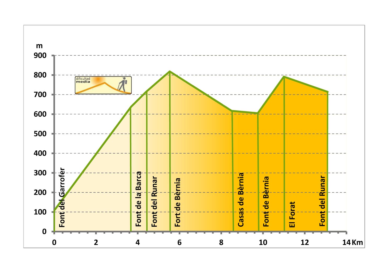
Start: Font de Garroferet, Altea la Vella.
Finish: Font del Runar.
Route Length: 13.1 kilometers.
Approximate Time: 4 hours.
Difficulty: Medium.
Cartography: Benidorm L 30-33 (848).
Bibliography: Topoguía PRV-7. Valencia Hiking Centre
Webgraphy: Federació d’Esports de Muntanya i Escalada de la C.V. http://femecv.com/senderos/pr-cv-7
Instituto Cartográfico Valenciano/ Institut Cartogràfic Valencià http://terrasit.gva.es
Services
Altea Town Council: Tel. No.: 965 84 13 00, e-mail: alcaldia@altea.es
Altea Tourist Information Office: Tel. No.: 965 84 41 14, e-mail: altea_gestion@gva.es -
altea@touristinfo.net
Valencia Hiking Centre: Tel. No.: 963 91 16 43, e-mail: infocev@centroexcursionista.org
Mountain and Climbing Sports Federation (Federació d’Esports de Muntanya i Escalada): Tel. No.: 965 43 97 47, e-mail:
femecv@femecv.com
Relief
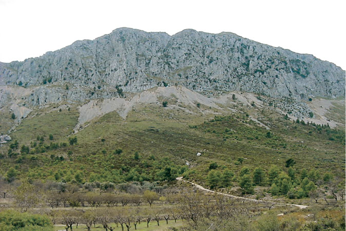
 Sierra/Serra de Bèrnia has a sub-betic origin, with a SW-NE orientation up to its maximum
height, turning NW-SE as it gets closer to the sea. It divides the regions of Marina Alta and
Marina Baixa, and is approximately 9 km long between the valley of the Algar river and the
ravine of Mascarat. The breathtaking pass of the Bandoleros separates it from the Ferrer
Mountains. The Bèrnia Mountains is a sharp limestone anticline from the Oligocene and the
Cretaceous, complicated by numerous intertwining faults; in line with these the Mascarat
ravine opens up, through an impressive gully spectacularly crowned by steep rocky formations
that gain their maximum altitude at Bèrnia peak (1126 m.)
Sierra/Serra de Bèrnia has a sub-betic origin, with a SW-NE orientation up to its maximum
height, turning NW-SE as it gets closer to the sea. It divides the regions of Marina Alta and
Marina Baixa, and is approximately 9 km long between the valley of the Algar river and the
ravine of Mascarat. The breathtaking pass of the Bandoleros separates it from the Ferrer
Mountains. The Bèrnia Mountains is a sharp limestone anticline from the Oligocene and the
Cretaceous, complicated by numerous intertwining faults; in line with these the Mascarat
ravine opens up, through an impressive gully spectacularly crowned by steep rocky formations
that gain their maximum altitude at Bèrnia peak (1126 m.)
Itinerary
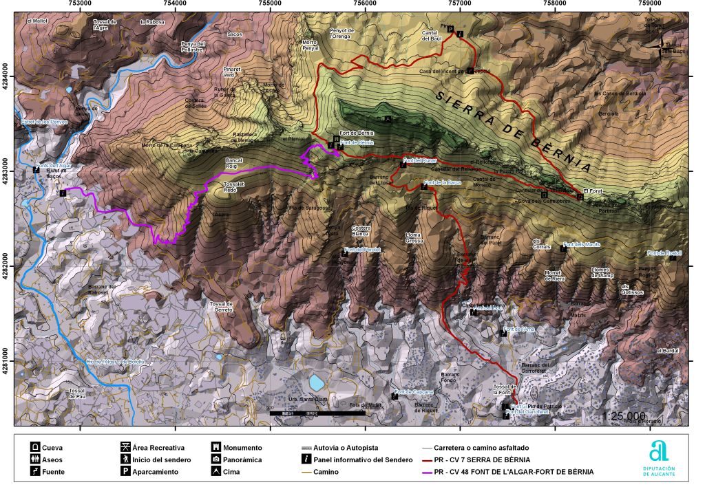 The trail begins at Font del Garrofer (Altea la Vella). At this point we can observe the vertical
sign showing the direction of the hike. It starts off with an asphalted segment leading us to the
urban settlement of Alhama Spring. Then, a very winding road takes us to the higher part of
the Les Penyes ravine. The trail goes about between abandoned crop patches to arrive at a
small recreational area. From this location, an asphalted segment first and then a trail, will take
us to the Font del Runar. A circular trail starts (or ends) at this spot. To walk this trail we must
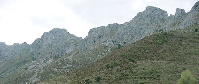
take the direction to The Fort, following the signposting available. Fort de Bèrnia is the ruins of
a fortress commissioned by Felipe II to control the potential uprising of the Moors. Following
the trail, and changing slopes, we will arrive at Casas de Bèrnia, Font de Bèrnia and El Forat
sites. The latter on there is a spectacular cavity that goes across the top of the Bèrnia
Mountains. Finally, passing through El Forat, we arrive at the location where we will start the
circular trail.
The trail begins at Font del Garrofer (Altea la Vella). At this point we can observe the vertical
sign showing the direction of the hike. It starts off with an asphalted segment leading us to the
urban settlement of Alhama Spring. Then, a very winding road takes us to the higher part of
the Les Penyes ravine. The trail goes about between abandoned crop patches to arrive at a
small recreational area. From this location, an asphalted segment first and then a trail, will take
us to the Font del Runar. A circular trail starts (or ends) at this spot. To walk this trail we must
take the direction to The Fort, following the signposting available. Fort de Bèrnia is the ruins of
a fortress commissioned by Felipe II to control the potential uprising of the Moors. Following
the trail, and changing slopes, we will arrive at Casas de Bèrnia, Font de Bèrnia and El Forat
sites. The latter on there is a spectacular cavity that goes across the top of the Bèrnia
Mountains. Finally, passing through El Forat, we arrive at the location where we will start the
circular trail.