Region: L’Alcoià and El Comtat.
Municipalities: Onil, Alcoi, Concentaina and Ibi.
Responsible Body: Diputación de Alicante. Environment and Solid Waste Area.
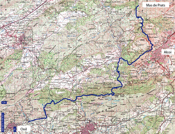
Start: Más del Prats.
Finish: Casa Tapena.
Length: 36.8 kilometers.
Approximate Time: 8 hours.
Difficulty: High.
Cartography: 820-IV 1:25,000; 846-II 1:25,000; 821-III 1:25,000.
Bibliography: Montañas Valencianas V. Comarcas Alicantinas; Rafael Cebrián. Ed. Papers de Muntanya, 1994.
Services
Diputación de Alicante: Tel. No.: 965 10 74 00
Onil Town Council: Tel. No.: 965 56 44 86
Alcoi Town Council: Tel. No.: 965 54 52 11
Cocentaina Town Council: Tel. No.: 965 59 00 51
Ibi Town Council: Tel. No.: 965 55 24 50
Relief
The Mariola Mountains are the second mountain system in the Alicante province second only to the Aitana Mountains due to their height and extension. They are one of the main lungs in the province of Alicante, with a rich wealth of flora and wildlife. The features of its relief were key to the settlement of a large number of peoples and civilisation in the past. From an administrative point of view, it belongs to the municipalities of Alcoy, Cocentaina, Muro de Alcoy, Agres, Alfafara, Bocairent and Bayneres de Mariola. The highest point is the Montcabrer peak (1389 m.), which rises in the municipal territory of Cocentaina. The Mariola Mountains provide the sources for most of Alicante’s hydrographical network.
Itinerary
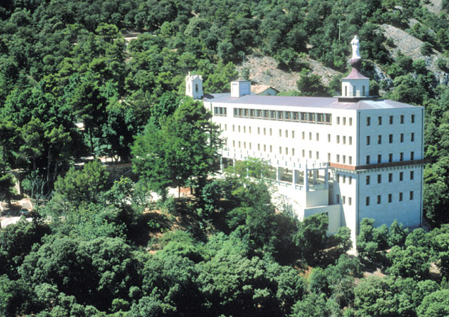
The trail begins at the Mas de Prats estate. From the Casa de los Capellanes, the PRV-160 coincides with the GR-7 route. We will pass through the Casas de Villaplana and the Barranc del Sinc. Leavng this ravine behind, we will set out to the Preventori along road CV-796. The trail continues to Castellar Height, Venta de losPatos and Ermita de Barxell. Upon crossing the Polop river, we will ascend to Casa Gelat farm house and to Font Roja Sanctuary. The trail leads to Menetjador summit, to further go down to Venta de los Cuernos, the Taguenga ravine and the Santa Ana recreational area, the end of our route.
 Senderos a Pie - Guía de Senderos de pequeño recorrido por la Provincia de Alicante

 Features
 The Mariola Mountains are the second mountain system in the Alicante province second only to the Aitana Mountains due to their height and extension. They are one of the main lungs in the province of Alicante, with a rich wealth of flora and wildlife. The features of its relief were key to the settlement of a large number of peoples and civilisation in the past. From an administrative point of view, it belongs to the municipalities of Alcoy, Cocentaina, Muro de Alcoy, Agres, Alfafara, Bocairent and Bayneres de Mariola. The highest point is the Montcabrer peak (1389 m.), which rises in the municipal territory of Cocentaina. The Mariola Mountains provide the sources for most of Alicante’s hydrographical network.